










Anschuetz has added the Generic Overlay feature, which extends SYNAPSIS (W)ECDIS NX by enabling the direct display of external, geo-referenced data within the chart. Third-party systems can provide their information as overlay
Anschuetz has added the Generic Overlay feature, which extends SYNAPSIS (W)ECDIS NX by enabling the direct display of external, geo-referenced data within the chart. Third-party systems can provide their information as overlay layers, visualized seamlessly alongside standard navigational data in a consistent spatial context.
Based on a standardized, generic interface, external applications can be connected to the Electronic Chart Display and Information System (ECDIS) itself without any modification. Once integrated, the system adapts automatically, generating menus, controls and visual elements dynamically in line with the connected data source.
Practical application: forward-looking sonar
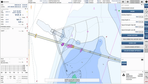
The first implementation of Generic Overlay integrates FarSounder’s 3D forward-looking sonar into SYNAPSIS ECDIS NX. Real-time detection of in-water targets and seabed structures is displayed directly on the chart, complementing existing navigational information.
Operators can differentiate clearly between underwater objects, such as rocks or obstacles, and seabed depth information, with visualization adapted to signal strength and depth ranges. Both live and historical data can be accessed and controlled independently, allowing users to assess current conditions while maintaining spatial context.
The result is an improved understanding of the environment ahead of the vessel. In practical scenarios such as port approaches, anchoring or navigation in poorly charted waters, forward-looking information
Content Original Link:
" target="_blank">